Extreme Cold
Table of Contents
Because many incidents of extremely cold temperatures in Kentucky have accompanied other severe winter weather events, this section will focus only on the temperature element, of which there is limited information available to report.
What constitutes extreme cold and its effect varies across different areas of the United States. In areas unaccustomed to winter weather, near freezing temperatures are considered “extreme cold.” In the north, below zero temperatures may be considered as “extreme cold.” Extreme cold often accompanies a winter storm or is left in its wake.
Description
There is no clear definition of extreme cold in the U.S. It is more of a relative term than a strict one. For example, in the American southeast freezing temperatures may be considered “extreme cold” because these communities experience freezing temperatures infrequently and are less prepared for cold events.
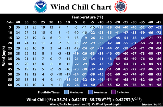
When cold temperatures are paired with intense winds, one’s body has even greater difficulty staying warm. Wind can make a freezing day feel substantially colder and can lead to cold-related conditions and even death. The National Weather Service developed the following wind chill chart to explain this effect:

Source: National Weather Service
Extent + Past Events + Location
In cold winter months, National Weather Service weather forecast offices routinely issue two types of alerts to warn people about dangerously low wind chill temperatures.
- Wind chill watch: issued when wind chill temperatures are potentially hazardous.
- Wind chill warning: issued when wind chill temperatures are life threatening.
However, temperature criteria for an advisory or warning can vary from state to state to reflect regional climate differences. Because of the relative nature of what constitutes extreme cold, KIPDA has decided to use wind chill watches and wind chill warnings as a measure of extent in the region.
Since 2010, the KIPDA region has experienced two wind chill warnings (2014, 2015) and one wind chill watch (2014). The two watches and one warning were issued for each county in the region [1]. The dates of the wind chill warnings and watch were obtained from the Iowa Environmental Mesonet. The Iowa Environmental Mesonet is a product of Iowa State University, and it collects national environmental data from cooperating members within observing networks. KIPDA employed data on wind chill watch and warnings from the Iowa Environmental Mesonet because the NOAA’s National Center for Environmental Information (NCEI) did not have any records for wind chill and warning events within the KIPDA region in the past 20+ years.
Probability
Occurrence
Between 2010 and 2020,each county in the KIPDA region experienced 2 cold warning events over 11 years. Therefore, each county in the KIPDA region has a 18% chance of receiving a cold warning annually. Wind chill warnings occur at the county and not city level.
Climate Change
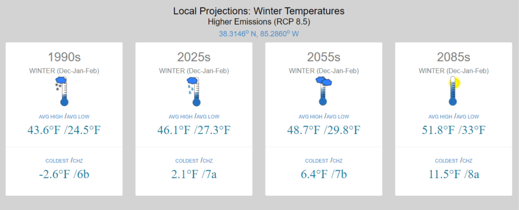
It is unclear if climate change will impact the number of extreme cold events in the KIPDA region. As shown in the graphic below, the mean temperature during winter months is increasing. Therefore, the KIPDA region can expect fewer days below freezing, but this does not necessarily translate to fewer extreme cold events. Climate change increases the frequency of unexpected, extreme events like an extreme cold event.
This graphic was generated from University of California Irvine’s Climate Toolbox site. KIPDA staff selected a general location in the KIPDA region (between Taylorsville and Shelbyville) and selected a higher emissions scenario (RCP 8.5) to develop the projection. The 1990s figure is based off of historical records for the area, while the the other temperatures are projections from University of Idaho’s gridMET dataset.

Source: Hegewisch, K.C., Abatzoglou, J.T., ‘ Future Climate Dashboard’ web tool. Climate Toolbox (https://climatetoolbox.org/) accessed on July 25, 2021.
Overall Probability
Overall, the KIPDA HMP ranks the probability of an extreme cold event occurring in the region as moderate to high because of past events and the impacts of climate change.
Impact
Between 2010 and 2020, the KIPDA region experienced two wind chill warnings that were in effect for all KIPDA counties. The first occurred on January 14, 2014, and the second happened on February 18, 2015. KIPDA used the Iowa Mesonet to find these dates because NCEI did not have any records for wind chill and warning events within the KIPDA region in the past 20+ years. NCEI incudes the number of deaths or injuries associated with an event; however, the Iowa Mesonet does not. Therefore, impacts from the 2014 and 2015 events are not entirely known. However, extreme cold is typically a regional event, and other counties/zones had data on the NCEI database for extreme cold events on those dates. Therefore, KIPDA uses information from nearby counties to extrapolate on extreme cold impacts.
- January 14, 2014: Greenup, Boyd, Carter, and Lawrence zones/counties experienced an extreme cold/wind chill event. 0 injuries and 0 deaths were reported. [2]
- February 18, 2015: Greenup, Boyd, Carter, and Lawrence zones/counties experienced an extreme cold/wind chill event. 0 injuries and 0 deaths were reported. [2]
Vulnerability
- Cold temperatures can potentially cause frostbite and hypothermia.
- Homeless people are at a higher risk for frostbite or hypothermia as they are more likely to be outside and without shelter in the winter time. However, the KIPDA region (excluding Jefferson County) has low levels of homeless people as it is mostly suburban and rural.
- Individuals without heat are particularly vulnerable to the effects of extreme cold especially older adults, persons with disabilities that limit mobility, and infants.
- Extreme cold and weather associated with extreme cold such as ice storms can lead to power outages, which can impact businesses, individuals, etc. These power outages are particularly dangerous because such events can cut off people’s access to heat, which increases the likelihood of cold-related illnesses like frostbite and hypothermia. Moreover, people may resort to using space heaters or their car’s heater. Both of these strategies can lead to carbon monoxide poisioning.
- Freezing temperatures and repeated freeze thaw cycles can lead to an increased number of potholes.
- Cold temperatures can also cause pipes to burst, which can impact utilities.
- Extreme cold and weather associated with extreme cold such as ice storms can lead to power outages, which can impact businesses, government entities, etc.
- Wild animals are vulnerable to the same cold disorders as humans, including mortality.
- Extreme cold events, especially later in the winter, can impact potential plant growth.
Hazard Vulnerability summary analysis
Extreme cold is a non-spatial hazard, and the entire planning area is equally vulnerable. It should be noted that several emergency managers in the region listed extreme cold coupled with ice events as particularly concerning. This is because ice events can easily take out power sources, and leave residents in homes without power during very cold temperatures.
Clair Brendel, the Regional Planning & Preparedness Manager for the American Red Cross Kentucky region, is more concerned about extreme cold rather than extreme heat events in the KIPDA region. While extreme cold events occur less frequently than extreme heat events in the KIPDA region, they can be more challenging. She makes this argument because heat peaks during the day when people can use public libraries, pools, groceries, etc. to cool down. Meanwhile, cold events peak at night when people have limited access to public places to stay warm.
Because of local concern and the frequency of events, the KIPDA region experiences a moderate to high vulnerability to extreme cold events.
- Bullitt County experienced two wind chill warnings since 2010.
- Bullitt County has 6.4% of adults over 65.
- Bullitt County has 29.7% of adults with a disability.
Because of these factors, Bullitt County experiences moderate to high vulnerability to extreme cold events. Bullitt County’s cities reflect Bullitt County’s overall demographic profile, and therefore experience moderate to high vulnerability as well.
- Henry County experienced two wind chill warnings since 2010.
- Henry County has 17.3% of adults over 65.
- Henry County has 36.4% of adults with disabilities.
Because of these factors, Henry County experiences moderate to high vulnerability to extreme cold events. Henry County’s cities reflect Henry County’s overall demographic profile, and therefore experience moderate to high vulnerability as well.
- Oldham County experienced two wind chill warnings since 2010.
- Oldham County has 14.8% of adults over 65.
- Oldham County has 20.1% of adults with disabilities.
Because of these factors, Oldham County experiences moderate to high vulnerability to extreme cold events. Oldham County’s cities reflect Oldham County’s overall demographic profile, and therefore experience moderate to high vulnerability as well.
- Shelby County experienced two wind chill warnings since 2010.
- Shelby County has 15.1% of adults over 65.
- Shelby County has 24.6% of adults with disabilities.
Because of these factors, Shelby County experiences moderate to high vulnerability to extreme cold events. Shelby County’s cities reflect Shelby County’s overall demographic profile, and therefore experience moderate to high vulnerability as well.
- Spencer County experienced two wind chill warnings since 2010.
- Spencer County has 12.9% of adults over 65.
- Spencer County has 24.2% of adults with disabilities.
Because of these factors, Spencer County experiences moderate to high vulnerability to extreme cold events. Spencer County’s cities reflect Spencer County’s overall demographic profile, and therefore experience moderate to high vulnerability as well.
- Trimble County experienced two wind chill warnings since 2010.
- Trimble County has 17.3% of adults over 65.
- Trimble County has 22.3% of adults with disabilities.
Because of these factors, Trimble County experiences moderate to high vulnerability to extreme cold events. Trimble County’s cities reflect Trimble County’s overall demographic profile, and therefore experience moderate to high vulnerability as well.
References
[1] Iowa State University (2021). Archived NWS Watch, Warnings, and Advisories, 2010-2020. [Data set]. Iowa Environmental Mesonet. Retrieved from: https://mesonet.agron.iastate.edu/request/gis/watchwarn.phtml
[2] National Oceanic and Atmospheric Administration (2021). Storm Events Database. [Data set]. National Centers for Environmental Information. Retrieved from: https://www.ncdc.noaa.gov/stormevents/
