Dams, though providing many benefits, can pose a risk to communities if not designed, operated, and maintained properly. In the event of a dam failure, the energy of the water stored behind even a small dam is capable of causing loss of life and significant property damage if there are people downstream of the dam. The National Dam Safety Program is dedicated to protecting the lives of citizens and their property from the risks associated with the development, operation, and maintenance of America’s dams.
There are more than 87,000 dams in the United States, the majority of which are privately owned. Other owners are state and local authorities, public utilities, and federal agencies. The benefits of dams are numerous; providing water for drinking, navigation, and agricultural irrigation. Dams also provide hydroelectric power and create lakes for fishing and recreation. Most importantly, dams are vital mitigation efforts that save lives by preventing or reducing floods.
Description
Types of dams
- Embankment dams: Embankment dams are the most common type of dam in use today. Materials used for embankment dams include natural soil or rock, or waste materials obtained from mining or milling operations. An embankment dam is termed an “earthfill” or “rockfill” dam depending on whether it is comprised of compacted earth or mostly compacted or dumped rock.
- Concrete dams: Concrete dams may be categorized as gravity and arch dams according to the design used to resist the stress of reservoir water pressure. The mass weight of concrete and friction resist the reservoir water pressure. A buttress dam is a specific type of gravity dam in which the large mass of concrete is reduced, and the forces are diverted to the dam foundation through vertical or sloping buttresses. Gravity dams are constructed of vertical blocks of concrete with flexible seals in the joints between the blocks.
- Concrete arch dams: Concrete arch dams are typically rather thin in cross-section. The reservoir water forces acting on an arch dam are carried laterally into the abutments. The shape of the arch may resemble a segment of a circle or an ellipse, and the arch may be curved in the vertical plane as well. Such dams are usually constructed of a series of thin vertical blocks that are keyed together; barriers to stop water from flowing are provided between blocks. Variations of arch dams include multi-arch dams in which more than one curved section is used, and arch-gravity dams which combine some features of the two types of dams.
Causes of failure
- Prolonged rainfall and flooding
- Inadequate spillway capacity, which leads to overtopping flows
- Internal erosion due to embankment or foundation leakage of piping
- Improper maintenance such as failing to remove trees, repair internal seepage problems, replace lost material
- Improper design
- Negligent operation such as failing to remove open gates or valves during high flow periods
- Failure of upstream dams
- High winds, which can cause waves that lead to substantial erosion [Eno-Haw Risk Assessment]
Types of failures
- Hydraulic Failure: Hydraulic failures result from the uncontrolled flow of water over the dam, around the dam and adjacent to the dam, and the erosive action of water on the dam and its foundation. Earth dams are particularly vulnerable to hydraulic failure since earth erodes at relatively small velocities.
- Seepage Failure: All dams exhibit some seepage that must be controlled in velocity and amount. Seepage occurs both through the dam and the foundation. If uncontrolled, seepage can erode material from the foundation of an earth dam to form a conduit through which water can pass. This passing of water often leads to a complete failure of the structure, known as piping.
- Structural Failure: Structural failures involve the rupture of the dam and/or its foundation. This is particularly a hazard for large dams and for dams built of low strength materials such as silts, slag, fly ash, etc. Dam failures generally result from a complex interrelationship of several failure modes. Uncontrolled seepage may weaken the soils and lead to a structural failure. Structural failure may shorten the seepage path and lead to a piping failure. Surface erosion may lead to structural or piping failures.
Signs of potential failure
- Seepage: The appearance of seepage on the downstream slope, abutments, or downstream area is cause for concern. If the water is muddy and is coming from a well-defined hole, material is probably being eroded from inside the embankment and a potentially dangerous situation can develop.
- Erosion: Erosion on the dam and spillway is one of the most evident signs of danger. The size of erosion channels and gullies can increase greatly with slight amounts of rainfall.
- Cracks: Cracks are of two types: traverse and longitudinal. Traverse cracks appear perpendicular to the axis of the dam and indicate settlement of the dam. Longitudinal cracks run parallel to the axis of the dam and may be the signal for a slide, or slump, on either face of the dam.
- Slides and slumps: A massive slide can mean catastrophic failure of the dam. Slides occur for many reasons and their occurrence can mean a major reconstruction effort.
- Subsidence: Subsidence is the vertical movement of the foundation materials due to failure of consolidation. Rate of subsidence may be so slow that it can go unnoticed without proper inspection. Foundation settlement is the result of placing the dam and reservoir on an area lacking suitable strength, or over collapsed caves or mines.
- Structural Conduit: Separations or ruptures can result in water leaking into the embankment and subsequent weakening of the dam. Pipe collapse can result in hydraulic failures due to diminished capacity.
- Vegetation: A prominent danger signal is the appearance of “wet environment” types of vegetation such as cattails, reeds, mosses and other wet area vegetation.
- Boils: Boils indicate seepage water exiting under some pressure and typically occur in areas downstream of the dam.
- Animal Burrows: Animal burrows are a potential danger since such activity can undermine the structural integrity of the dam.
- Debris: Debris on dams and spillways can reduce the function of spillways, damage structures and valves, and destroy vegetative cover.
Flooding
Dam failures cause flooding much different from natural flooding. A flood from a dam failure may arrive before any warning or evacuation can take place and the resulting wall-of-water makes evacuation based on limited environmental cues very problematic. The failure of large dams results in flooding with enough energy to damage or destroy residences and other structures.
Technological Hazard Note
Dams are a technological hazard not a natural hazard, but they are tied to flooding. They can be impacted by flooding or create flooding in area. Therefore, dams function more as a subcomponent of flooding than a standalone hazard.
Location + Extent
Dams are located across the KIPDA region. Use the Tableau dashboard below to see their locations by county.
Dam data is from the KY Division of Water's regulated dams layer and the
National Inventory of Dams.
Dam Severity
The most prominent indicator of dam failure severity is its classification, which describes the likelihood of the dam’s failure impacting property and human life. Please note that classification is not an indicator of whether or not a dam will fail. Rather it is an indicator of the impact the dam would have if it were to fail. Dams have the following classifications:
- Low: Failure is unlikely to result in loss of life and only minor increases to existing flood levels at road and buildings is expected.
- Significant: Failure could possibly result in loss of life or increase flood risks to roads and buildings with no more than 2 houses impacted and less than six lives in jeopardy.
- High: Failure would likely result in loss of human life, extensive property damage to homes and other structures, or cause flooding of major highways such as state roads or interstates.
Each county in the KIPDA region has 2-4 high hazard dams, the dams most likely to result in significant loss.
Past Events & Impacts
According to the National Performance of Dams Program’s database, one (1) dam malfunction was reported in the KIPDA region since 1973. This incident occurred at Guist Creek Lake on March 1, 1997. This malfunction did not cause any significant damage and was due to an inflow flood.
Probability
Age
In 2019, the American Society of Engineers gave Kentucky’s dam infrastructure a D+ (on an A-F grading scale), which is slightly higher than the national average of a D. Any D rating indicates that infrastructure “is in poor to fair condition and mostly below standard, with many elements approaching the end of their service life” [1]. Many dams in Kentucky are approaching the end of their service life as the majority are over 50 years. For state-owned dams, the average age is 52 years. Dams built 50 years ago typically have a life span of 50 years, which means that many dams in the state are past their life span [1].
Condition
The state inspects high hazard dams every few years and rates their condition. The following high hazard dams are in poor or unsatisfactory condition (broken down by county):
- Bullitt: (3 total) -Bullitt County Sportsmen’s Club Dam (poor) -Lake Nevin Dam (poor) -Gilbert Dam (poor)
- Henry (1 total): Eminence Lake Dam (poor)
- Oldham (2 total): Harmony Lake Dam (unsatisfactory) and Lower Eagle Creek Golf Course Dam (poor). Lower Eagle Creek Dam in La Grange is the only dam within city boundaries that is classified as high hazard and in poor condition.
- Shelby (1 total): Guist Creek Lake Dam (poor)
- Spencer (1 total): Wallitsch Dam (poor)
- Trimble (0 total)
Source: National Inventory of Dams
Climate Change
In some regions, climate change is causing an increase in precipitation in the form of rainfall [2]. These changes in hydrological conditions are creating stress on dams that were not built to withstand such amounts of water. Increased rainfall and increased streamflow into reservoirs also creates an influx of sedimentation, which limits the functionality of the dam and degrades its performance [3]. As a whole, dams in the US were built between 1950-1980 and are not engineered to withstand the effects of climate change.
Combined data from the National Climate Assessment and the Army Corps of Engineers predicts that regions northeast, east and south of the Ohio River will experience an increase in precipitation in the form of rainfall by 40-50% by the year 2100. [4-6]
Overall Probability
Overall, the KIPDA HMP ranks the probability of an event for the region as moderate. While a major event has not happened in the past 50 years, the age of dam infrastructure, number and condition of high hazard dams, and climate change are increasing the likelihood of a significant dam failure happening.
Vulnerability
Inundation Zones
The Kentucky Division of Water (DOW) modeled the inundation zones for high hazard dams in Kentucky. These areas are the most vulnerable to being damaged or destroyed by flooding from the failure of a high hazard dam. KIPDA GIS staff then used spatial analysis to intersect building footprints for the KIPDA region with the inundation areas. Therefore, this map displays the locations of properties that are most vulnerable following a dam failure event and DOW’s inundation zones.
Type in an address or city name to the search icon on the top right or zoom into the map using the + button on the bottom right to better view the building footprints.
*Please note that this map only uses inundation areas for high hazard dams that are regulated by DOW. Inundation zones for high hazard dams regulated by the U.S. Army Corps of Engineers and other federal and state agencies are not shown on the map.
Methodology
Inundation Areas: Inundation area data was developed using conservative, screening level analyses. Models used include DSS- WISE Lite and FEMA GeoDAMBREACH. More advanced, precision methods exist. The inundation zones are for general informational purposes only and should not be used for emergency planning or decision making.
Building Footprints: These building footprints are a subset of the Microsoft Building Footprints – Features layer, available on ArcGIS online and updated Jan 11, 2019. The subset includes all building footprints that fall within or intersect the Kentucky Division of Water – Regulated Dams Inundation Areas layer.
Data Limitations
Please note that KIPDA does not have access to the value of any of the buildings identified in the map above. It also does not have future building footprints, and therefore the vulnerability of future development is unknown.
Inundation Vulnerability
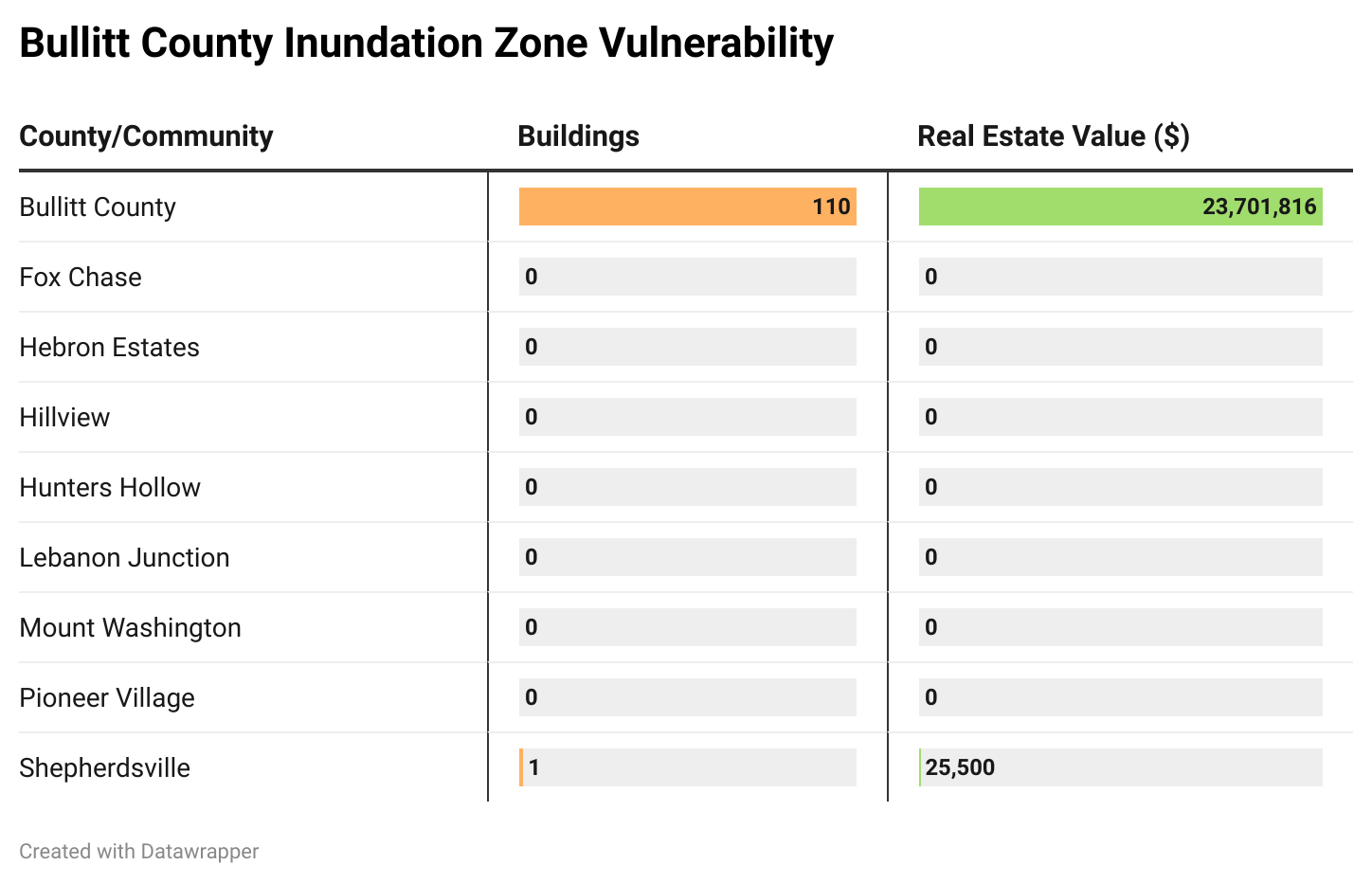
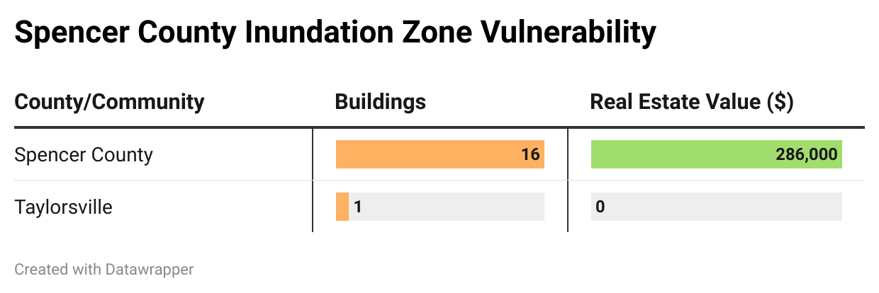
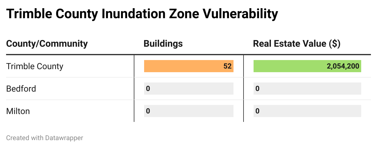
In order to generate approximate estimates of property value located within KIPDA HMP Inundation zones, 2018 Microsoft Bing Building Footprints were compared with KIPDA HMP Inundation zone boundaries. The building footprints which intersected the Inundation zone polygons were selected and identified as being potentially impacted during an event. The impacted building footprints were then joined with PVA parcel data to assign a value of potential losses during a catastrophic/total loss scenario.
As some are buildings are built very close to the parcel boundaries, the process created a handful of duplicate entries, where parcel boundaries crossed over buildings. Both the buildings and parcel data sets are imperfect, but the best available information at the time of plan creation. Duplicates were evaluated visually, and the most correct parcels based on available information were kept, and the most incorrect were deleted. Summary statistics were used to generate counts of the number of buildings impacted as well as the total parcel value for each building.
These values assume that the entire parcel is a total loss. It is understood that this is incredibly likely to be an over-estimate as the land would remain after an event and most scenarios will not result in a total loss of the building(s). Parcels do not always exactly fit into this model because there can be multiple buildings on the parcel. Other parcels do not fit the criteria because they have no real-estate or improvement value associated with them. Some counties had different attributes assigned to their parcel data such as Real-Estate value versus Improvement value. Employee discretion was used to determine the most appropriate values to use given the available information per county.
Bullitt County
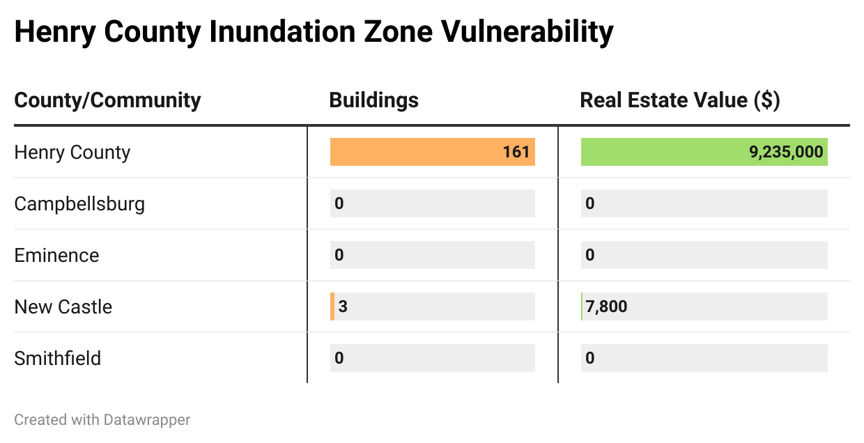
Henry County
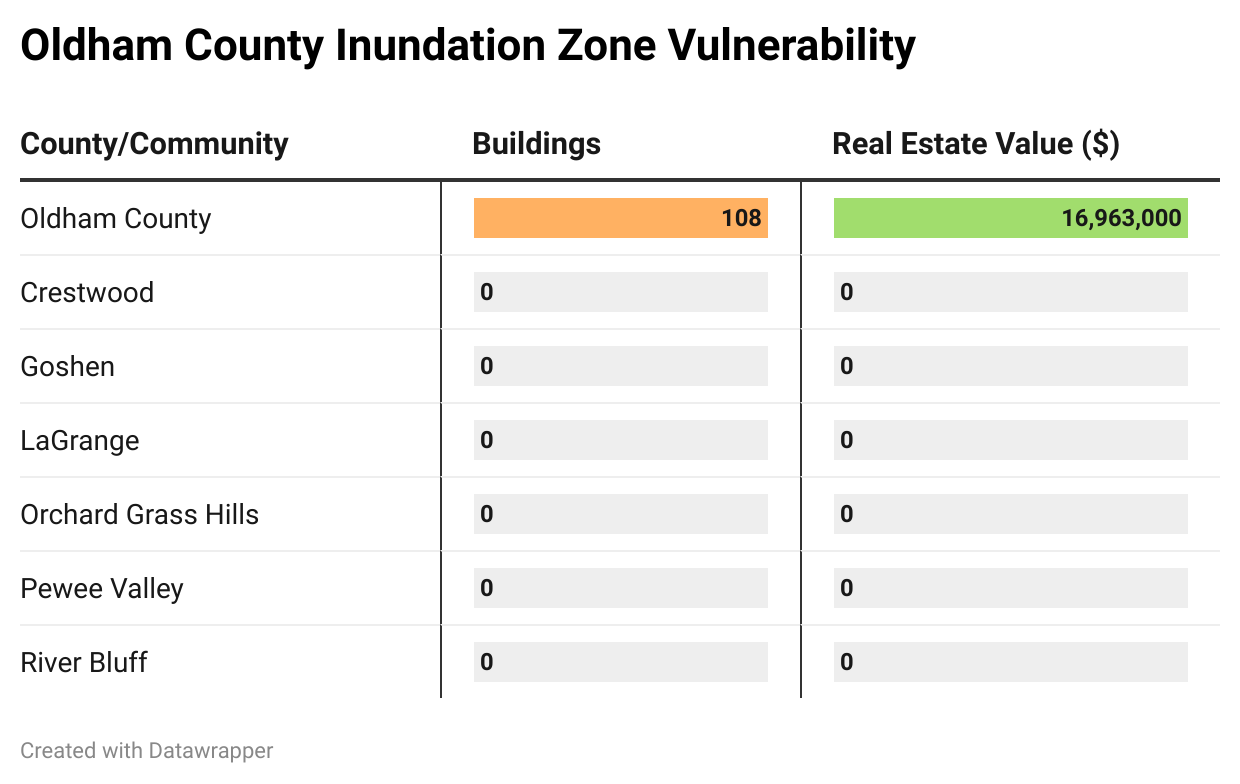
Oldham County
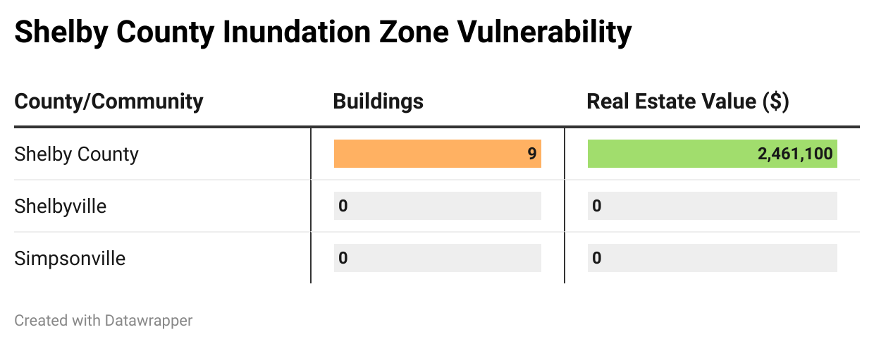
Shelby County
Spencer County
Trimble County
Emergency Action Plans
Emergency Action Plans formulate how to respond to a dam failure by providing information on evacuation zones, agencies to contact, resident contact lists, etc. Between 2010 and 2019, the state made a significant dent in the number of high hazard dams with EAPS. In 2010, 5% of state-owned dams had Emergency Action Plans, but by 2019 75% of state-owned high hazard dams had plans. However, it should be noted that Kentucky, unlike the majority of states, does not require high hazard dams to have emergency action plans. Therefore, 44 of Kentucky’s 177 state-regulated, high hazard dams do not currently have EAPs in place. Additionally, 98 high-hazard dams in the state are not state-regulated and may not have EAPs in place [1]. Without an EAP an event is more likely to cause significant damage because community leaders and owners of dams are unaware of who to contact, evacuate, etc.
Within the KIPDA region, not a single high hazard dam has a valid EAP. Little Kentucky River MPS 1 [Lake Jericho] and Lake Nevin used to have valid EAPs; however, their EAPS failed to pass the state audit in 2020. Guist Creek Lake has a preliminary EAP, but the state has been unable to complete it at this time due to limited resources.
- Social environment: Dam failure can cause spectacular destruction, which can potentially lead to injuries or deaths.
- Built environment: Dam failure obviously damages the dam itself and any public or private infrastructure that crosses the stream such as water and sewer lines. Dam failure can also severely damage or destroy both public and private property. Particularly vulnerable are those properties within the dam inundation zone.
- Natural environment: Dam failure can displace aquatic species, cause erosion, and disrupt habitats.
Hazard Vulnerability Summary Analysis
Communities in the KIPDA region experience moderate to high vulnerability to dam failure with each county containing 2-4 high hazard dams. Despite overall similarity in risk, there are slight differences between each community. Bullitt County is the most vulnerable to dam failure and Trimble County is the least vulnerable.
Use the accordion below to understand each county and its respective cities’ levels of risk.
Bullitt
Bullitt County and its cities experience moderate to high vulnerability to dam failure.
Bullitt County is the most vulnerable to dam failure within the KIPDA region because it contains the highest number, 3, of dams that are high hazard and in poor condition.
While Shepherdsville does not contain a dam within its boundaries, a very small portion of the city is within the inundation zone for the Lake Nevin Dam. This makes it more vulnerable than other cities in Bullitt County. Mount Washington, Fox Chase, Hebron Estates, Hillview, Hunters Hollow, and Pioneer Village, do not contain a high hazard dam and are not within an inundation zone for DOW-regulated dam.
Henry
Henry County and its cities experience moderate to high vulnerability to dam failure.
Henry has a higher proportion of dams (20) to people, which negatively impacts vulnerability.
While New Castle does not contain a dam within its boundaries, it is within the inundation zone for the Jerry Powell Dam, which is a high hazard dam. This makes it more vulnerable than other cities in Henry County, Campbellsburg, Eminence, and Pleasureville, which do not contain a high hazard dam and are not within an inundation zone for DOW-regulated dam.
Oldham
Oldham County and its cities experience moderate to high vulnerability to dam failure.
Oldham County contains 2 high hazard dams that are considered to be in poor or unsatisfactory condition, which increases its vulnerability to a failure event.
La Grange contains a high hazard dam in poor condition, which makes it the most vulnerable city within the region. Crestwood and Pewee Valley do not contain high hazard dams, which decreases their vulnerability.
Shelby
Shelby County and its cities experience moderate to high vulnerability to dam failure.
Shelby County has the highest number of dams, which increases the likelihood that it will experience a dam failure event. However, it contains only 1 high hazard dam in poor condition, which decreases its likelihood of experiencing a dam failure event.
Shelbyville and Simpsonville do not contain a high hazard dam, which decreases their vulnerability to experiencing a substantial event.
Spencer
Spencer County and its cities experience moderate to high vulnerability to dam failure.
Spencer has the second smallest number of dams, 9, and only one high hazard dam in poor condition, which makes the county less vulnerable to experiencing a major dam failure event.
Taylorsville is within an inundation zone for the Guist Creek Lake Dam, which is located in Shelby County. This means that Taylorsville is more vulnerable to experiencing a dam failure event.
Trimble
Trimble County and its cities experience moderate to high vulnerability to dam failure.
Trimble has the lowest level of vulnerability to dam failure because it has the fewest dams and the fewest number of high hazard dams. However, Milton is within the inundation for the Little Kentucky River Dam, which is a high hazard dam. This makes Milton Milton more vulnerable to dam failure. Bedford does not contain a dam and is not within an inundation zone, and therefore, it experiences less risk than Milton.
References
[1] American Society of Civil Engineers (2019). 2019 Report Card for Kentucky’s Infrastructure. Retrieved from: https://infrastructurereportcard.org/wp-content/uploads/2021/07/2019-ASCE-KY-Infrastructure-Report-updated.pdf
[2] Lee, B., & You, G. (2013, March 20). An assessment of long-term overtopping risk and optimal termination time of dam under climate change. Retrieved July 24, 2020, from https://www.sciencedirect.com/science/article/pii/ S0301479713001138? casa_token=PLqZxb118WcAAAAA%3ASgoAODu4COtOLpz40MMJuWCZWcd3l1 bKbFiqvs-5GeC2cEdc40BUM5mHnExGE6Wp4s2THmnWeg
[3] Fountain, H. (2020, May 21). ‘Expect More’: Climate Change Raises Risk of Dam Failures. Retrieved July 24, 2020, from https://www.nytimes.com/ 2020/05/21/climate/dam-failure-michigan-climate-change.html
[4] Hayhoe, K., Wuebbles, D. J., Easterling, D. R., Fahey, D. W., Doherty, S., Kossin, J. P., . . . Wehner, M. F. (2018). Chapter 2 : Our Changing Climate. Impacts, Risks, and Adaptation in the United States: The Fourth National Climate Assessment, Volume II. doi:10.7930/nca4.2018.ch2
[5] United States, US Army Corps of Engineers, Institute for Water Resources. (2017). Ohio River Basin: Formulating climate change mitigation/adaptation strategies through regional collaboration with the ORB Alliance. US Army Corps of Engineers. Retrieved July 24, 2020, from https://usace.contentdm.oclc.org/ digital/collection/p266001coll1/id/5108/.
[6] Bruggers, J. (2017, December 01). Army engineers warn of brutal future for Ohio River region from climate change. Retrieved July 24, 2020, from https:// www.courier-journal.com/story/tech/science/environment/2017/11/30/ ohio-river-valley-climate-change-report/831135001/
[7] Federal Emergency Management Agency (2004). Federal guidelines for dam safety: hazard potential classification system for dams. Retrieved July 26, 2021, from https://www.ferc.gov/sites/default/files/2020-04/fema-333.pdf
